Tiles
The GeoPackage standard adopts a tile-based pyramid structure for storing imagery and raster maps at multiple resolutions. An illustration of this structure is shown below.
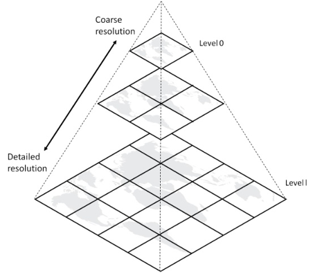
Figure 2: A tile pyramid
The GeoPackage tiles option specifies a mechanism for storing raster data in tile pyramids.
“Tile pyramid” refers to the concept of pyramid structure of tiles of different spatial extent and resolution at different zoom levels, and the tile data itself.
“Tile” refers to an individual raster image such as a PNG or JPEG that covers a specific geographic area.
“Tile matrix” refers to rows and columns of tiles that all have the same spatial extent and resolution at a particular zoom level.
“Tile matrix set” refers to the definition of a tile pyramid’s tiling structure.
This tile-based pyramid structure is particularly useful when handling a GeoPackage on small or constrained devices such as mobile phones, tablets or laptops because an appropriate resolution can be selected based on the zoom level and the device screen size. This mechanism is based on the model for tile matrix sets described in Section 6 of the WMTS Implementation Specification.
If tiles are to be included in a GeoPackage, there are two additional required metadata tables, gpkg_tile_matrix_set and gpkg_tile_matrix.
In addition to these tables, each tile pyramid requires a user-defined table that contains the actual tiles.
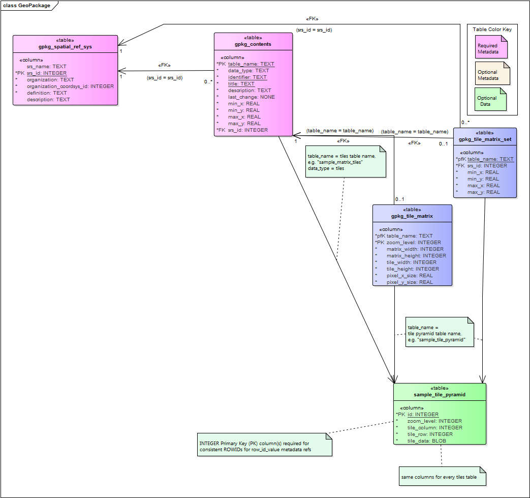
Figure 3: UML Diagram of Tiles tables
gpkg_tile_matrix_set
The gpkg_tile_matrix_set table describes names a tile matrix set (pyramid). The columns in this table are:
table_nameandsrs_idmatch the entries ingpkg_contentsmin_x,min_y,max_x, andmax_y: the actual spatial extents of the tile pyramid.
This is must be exact so that applications can use this information to geolocate tiles correctly.
(This is in contrast with the extents in gpkg_contents which are informative and are expected to reflect the extents of usable content.)
gpkg_tile_matrix
Each tile matrix set is composed of one or more tile matrices, each identified by its zoom level. The required columns in this table are:
table_namematches the entry ingpkg_contentsand elsewherezoom_levelindicates the zoom levels present in the file.matrix_widthandmatrix_heightdescribe the size of the tile matrix in tilestile_widthandtile_heightdescribe the size of each tile in pixelspixel_x_sizeandpixel_y_sizedescribe the size of each pixel
By default, zoom levels are separated by powers of two, but if this is inappropriate for your scenario, other multiples are possible by using the Zoom Other Levels extension.
User Data Tables
The physical tiles (data) are stored in user data tables with a specific schema. The required columns for these tables are:
idis a primary keyzoom_levelindicates which tile matrix this tile is part oftile_columnandtile_roware the zero-indexed tile numbertile_datais the BLOB containing the tile image
PNG and JPG are the two tile file types supported by the core standard.
PNG is generally better for synthetic data (i.e., digital maps) because it is lossless and its compression codec compresses synthetic data fairly well.
JPG is generally better for natural data (i.e., satellite or aerial imagery) due to its superior (though lossy) compression.
The WebP Extension allows for the use of WebP files which feature both transparency and improved compression, but WebP support is not as ubiquitous.
However, since PNG supports alpha transparency and JPG does not, it is common to use PNG tiles around the boundary of a tile pyramid. This allows users to see the data underneath the tile boundaries.
Note
JPG files have an adjustable compression rating. We have found that a ratings in the range 50-75 (out of 100) work best for imagery. Ratings that are too high use too much space and ratings that are too low have too many visible artifacts. Within the 50-75 range it is a reasonable tradeoff between file size and image quality.
By default, tiles pyramids are organized by powers of two. There are two common strategies for maximizing the storage space efficiency for tiles.
1. Tile pyramids may be sparsely populated. By leaving unnecessary tiles blank, clients can drop to the next zoom level to render that part of the map.
To further optimize storage efficiency, consider using the Zoom Other Intervals Extension and refine zoom levels to match the data and its intended use.