Content Types
What is in a GeoPackage
Like other relational databases, GeoPackages contain a number of tables. The following figure shows the mandatory and optional tables of a GeoPackage.
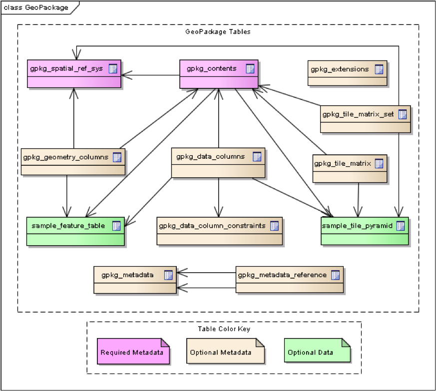
Figure 1: UML diagram of mandatory and optional GeoPackage tables
GeoPackage tables fall into two categories, metadata tables and user-defined data tables.
GeoPackages contain two mandatory metadata tables, gpkg_contents and gpkg_spatial_ref_sys.
The presence of other metadata tables is dictated by the content being stored (see next pages). The name of the user-defined data table is the primary key for gpkg_contents and generally is a foreign key for content-specific metadata tables.
gpkg_contents
The gpkg_contents table is the table of contents for a GeoPackage. The mandatory columns in this table are:
table_name: the actual name of the user-defined data table (this is also the primary key for this table)data_type: the data type, e.g., “tiles”, “features”, “attributes” or some other type provided by an extensionidentifieranddescription: human-readable text (“identifier” is analogous to “title”)last_change: the informational date of last change, in ISO 8601 format (for practical purposes, RFC3339 applies)min_x,min_y,max_x, andmax_y: the spatial extents of the content. (This is informational and often used by clients to provide a default view window.)srs_id: spatial reference system (see next subsection)
gpkg_spatial_ref_sys
For content that has spatial reference (including but not limited to tiles and features), each row in contents must reference a coordinate reference system which is stored in the gpkg_spatial_ref_sys table.
The mandatory columns in this table are:
srs_name,description: a human readable name and description for the SRSsrs_id: a unique identifier for the SRS; also the primary key for the tableorganization: Case-insensitive name of the defining organization e.g.,EPSGorepsgorganization_coordsys_id: Numeric ID of the SRS assigned by the organizationdefinition: Well Known Text definition of the SRS.
At least three rows must be in this table. There must be one row for each of the following srs_id column values:
4326: latitude and longitude coordinates on the WGS84 reference ellipsoid,
0: undefined geographic coordinate reference systems, and
-1: undefined Cartesian coordinate reference systems.
However, many other coordinate reference systems (CRSs) are possible. Using CRSs incorrectly is one of the most common ways to break GeoPackage interoperability. When in doubt, discuss CRSs with a geospatial expert to ensure that you are using an appropriate CRS for your situation.
Hint
Use the WKT for Coordinate Reference Systems Extension to express atypical CRSs.