
GeoPackage 1.0 Conformance Test Suite
Scope
This conformance test suite verifies the structure and content of a GeoPackage 1.0 data container. The GeoPackage 1.0 specification describes how a platform-independent SQLite database file may contain various types of content, including:
- vector geospatial features
- tile matrix sets of imagery and raster maps at various scales
- metadata
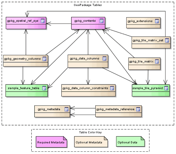
The basic structure of a GeoPackage database is shown in Figure 1.
Figure 1: GeoPackage tables
The following conformance classes have being defined (In bold the classes that have been implemented):
- Core (Required)
- SQLite Container
- Spatial Reference Systems
- Contents
- Features
- Tiles
- Schema
- Metadata
- Registered Extensions
- Features
- Tiles
Note: This test doesn’t support GeoPackage 1.1. To follow the issue or support the development of a 1.1 test, please provide a comment in the GitHub issue tracker.
Test requirements
The documents listed below stipulate requirements that must be satisfied by a conforming implementation.
If any of the following preconditions are not satisfied then all tests in the suite will be marked as skipped.
- The major version number in the SQLITE_VERSION_NUMBER header field is 3.
Test suite structure
The test suite definition file (testng.xml) is located in the root package,
org.opengis.cite.gpkg10. A conformance class corresponds to a <test> element, each
of which includes a set of test classes that contain the actual test methods.
The general structure of the test suite is shown in Table 1.
| Conformance class | Test classes |
|---|---|
| Core | org.opengis.cite.gpkg10.core.* |
| Tiles | org.opengis.cite.gpkg10.tiles.* |
The Javadoc documentation provides more detailed information about the test methods that constitute the suite.
Test run arguments
The test run arguments are summarized in Table 2. The Obligation descriptor can have the following values: M (mandatory), O (optional), or C (conditional).
| Name | Value domain | Obligation | Description |
|---|---|---|---|
| iut | URI | M | A URI that refers to a GeoPackage file. Ampersand ('&') characters must be percent-encoded as '%26'. |
| ics | A comma-separated list of string values. | O | An implementation conformance statement that indicates which conformance classes or options are supported. |